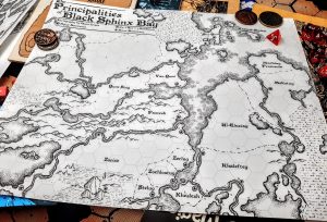

The third map of the Midsummer Lands is set directly to the south of the first one. The next three will all be inland from these three, producing a 3 tall by 2 wide “grid” of map sections that interlink.
As with all the maps in the set, there is no set scale for these maps, and the items on the maps are not to scale with each other so we can see points of interest like towers, cities, and caves. If you really need a scale for this and don’t want to pick one yourself, go with six miles to the hex.
 The Midsummer Lands – Hex Map 3” data-image-caption=”
The Midsummer Lands – Hex Map 3 (300 dpi promo)
” data-medium-file=”https://rpgcharacters.files.wordpress.com/2022/06/junehexes-3.jpg?w=300″ data-large-file=”https://rpgcharacters.files.wordpress.com/2022/06/junehexes-3.jpg?w=529″ src=”https://glossingdress.com/lib/img/all/549/f41e3c6a5b428544a391206480c5edb7604453764a45cebdfe20059c02036755/cd5f46eddc7b891c47eb62680fb1eb59c246e779d33533978565e13f56813ca1.jpeg” alt=”The Midsummer Lands – Hex Map 3″ class=”wp-image-23942″ srcset=”https://glossingdress.com/lib/img/all/549/f41e3c6a5b428544a391206480c5edb7604453764a45cebdfe20059c02036755/cd5f46eddc7b891c47eb62680fb1eb59c246e779d33533978565e13f56813ca1.jpeg 600w, https://rpgcharacters.files.wordpress.com/2022/06/junehexes-3.jpg?w=1200 1200w, https://rpgcharacters.files.wordpress.com/2022/06/junehexes-3.jpg?w=150 150w, https://rpgcharacters.files.wordpress.com/2022/06/junehexes-3.jpg?w=300 300w, https://rpgcharacters.files.wordpress.com/2022/06/junehexes-3.jpg?w=768 768w” sizes=”(max-width: 600px) 100vw, 600px” />
Here we are south of Bannersbridge in the hills that were once the foothills of the Keller Range. The hills along the small river are crawling with old ruins – many of immense size that have drawn the attention of adventurers and treasure hunters for ages. One old structure still stands from before the great war against the elves – a massive lighthouse across the bay from Griffon Point – a large fortified city built up around and over elven and giant ruins on a peninsula by the mouth of Clear River.
 The Midsummer Lands – Hex Map 3” data-image-caption=”
” data-medium-file=”https://rpgcharacters.files.wordpress.com/2022/06/junehexes-3.png?w=300″ data-large-file=”https://rpgcharacters.files.wordpress.com/2022/06/junehexes-3.png?w=529″ src=”https://glossingdress.com/lib/img/all/549/f41e3c6a5b428544a391206480c5edb7604453764a45cebdfe20059c02036755/42911632990062bd837421a9d3f46f586423c6d096910e153f203d8ff2cfda1b.png” alt=”The Midsummer Lands – Hex Map 3″ class=”wp-image-23943″ srcset=”https://glossingdress.com/lib/img/all/549/f41e3c6a5b428544a391206480c5edb7604453764a45cebdfe20059c02036755/42911632990062bd837421a9d3f46f586423c6d096910e153f203d8ff2cfda1b.png 600w, https://rpgcharacters.files.wordpress.com/2022/06/junehexes-3.png?w=1200 1200w, https://rpgcharacters.files.wordpress.com/2022/06/junehexes-3.png?w=150 150w, https://rpgcharacters.files.wordpress.com/2022/06/junehexes-3.png?w=300 300w, https://rpgcharacters.files.wordpress.com/2022/06/junehexes-3.png?w=768 768w” sizes=”(max-width: 600px) 100vw, 600px” />
Tied to Griffon Point by trade and military aid are Oxcross along the coast to the south, and Yellow Hill along the Clear River. Yellow Hill was an archeological dig site that uncovered a gate to an empty and desolate version of one of the yellow hells – workers travel through the heavily guarded gate daily to collect the yellow salts and to mine for other crystals. The lack of food and water in those thrice-baked planes under infinite suns means the work is gruelling and unpleasant, and shifts are four hours long at most.